

The Lousberg is the green ridge rising directly north of central Aachen, close enough to reach on foot from the old town yet high enough to look back over the rooftops. It is laid out as open parkland rather than a ticketed attraction, so there is no gate, no booking, and no opening time to plan around.
This guide covers where the hill sits and how it was shaped, the individual viewpoints and monuments along the way, and two concrete route options with distances and elevation from a documented hiking route. It also explains how to judge conditions before climbing and what the walk does and does not include.
One practical starting point: at 264 metres, the Lousberg is a striking elevation on the northern edge of the historic centre of Aachen, designed as a forest and mountain park at the beginning of the nineteenth century according to plans by Maximilian Friedrich Weyhe. A documented loop from Aachen runs about 8.4 kilometres with roughly 140 metres of climbing, which is community route data rather than an official park measurement.
Where the Lousberg Sits and How It Was Shaped
The hill stands on the northern edge of the historic centre, which is why you can begin walking from the city side rather than driving out to a trailhead. That proximity is the Lousberg's main advantage over Aachen's other high ground: the climb starts almost where the sightseeing ends.
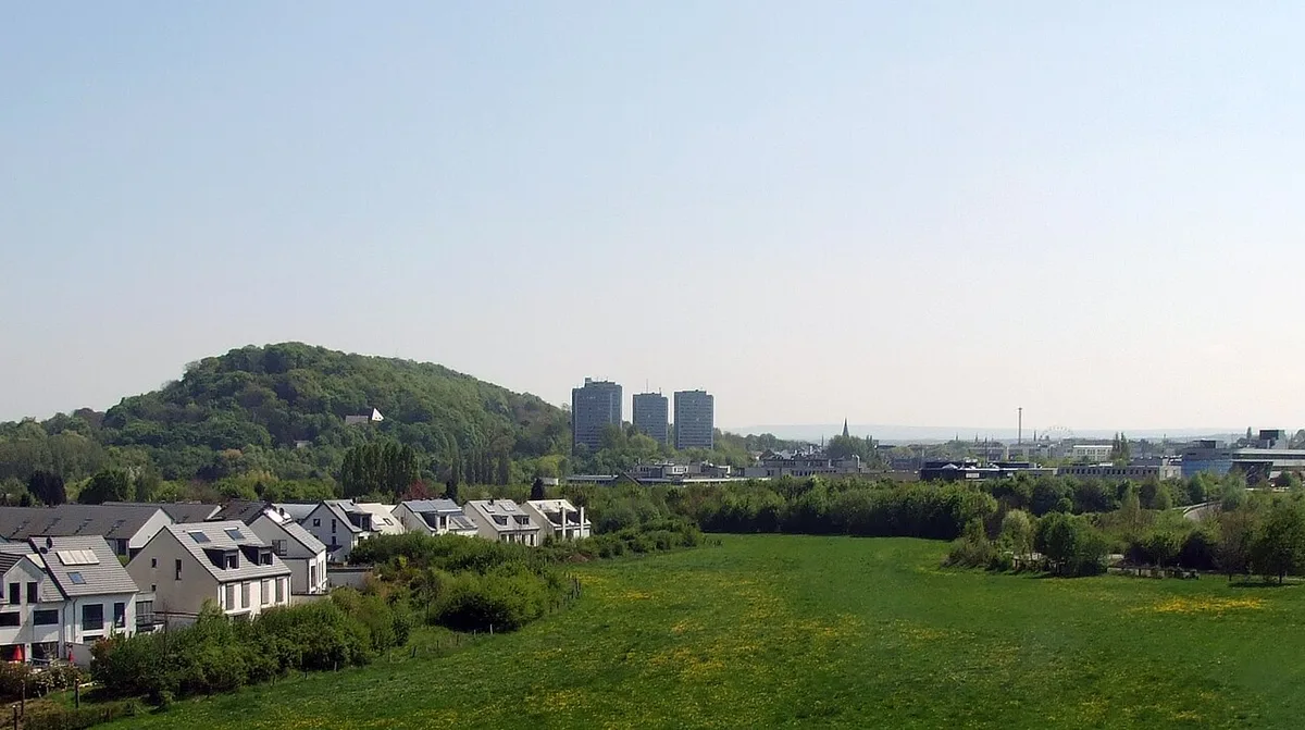
Its parkland character is not accidental. At 264 metres high, it is a striking elevation on the northern edge of the historic centre of Aachen, designed as a forest and mountain park at the beginning of the nineteenth century according to plans by Maximilian Friedrich Weyhe. It remains a wooded public park today rather than a manicured city garden or a sports ground.
Practically, that means a mix of shaded woodland paths, open viewpoints and stone monuments scattered along the ridge. You are walking through a designed landscape with history in it, so expect to stop at markers and plaques rather than treat the hill as a pure workout.
The Viewpoints and What You Can See
The viewpoints are spread along the route rather than concentrated at one summit platform, so the panorama unfolds in stages as you walk. Two of the documented ones look toward the Soers and toward the Town Hall, which gives you both the open valley and the old-town skyline in one outing.
There is also a sundeck equipped with swings that faces the Eifel Valley, a rest spot rather than a formal observation deck. On the same stretch you reach the Lousberg Terrace, where five free hammocks are set out for resting with a beautiful view, which is genuinely useful if you are walking with children or pacing yourself.
Because the viewpoints face different directions, you get more variety by walking through than by heading to a single point and turning back. If your priority is comparing panoramas across the city, it is worth reading up on the best viewpoints in Aachen before deciding how much of the hill to cover.
Monuments Along the Way: Obelisk, Columns and Legend
The walk strings together several monuments that give the route a narrative. The Tranchot Obelisk sits along the documented loop, and the Belvedere columns survive as the remainder of a structure on the hill that was destroyed in the Second World War.
Those remaining columns are affectionately nicknamed the Aachen Acropolis by locals because of their resemblance to ancient Greek architecture. It is a small monument, but it is one of the most photographed points on the hill and a natural place to pause before continuing.
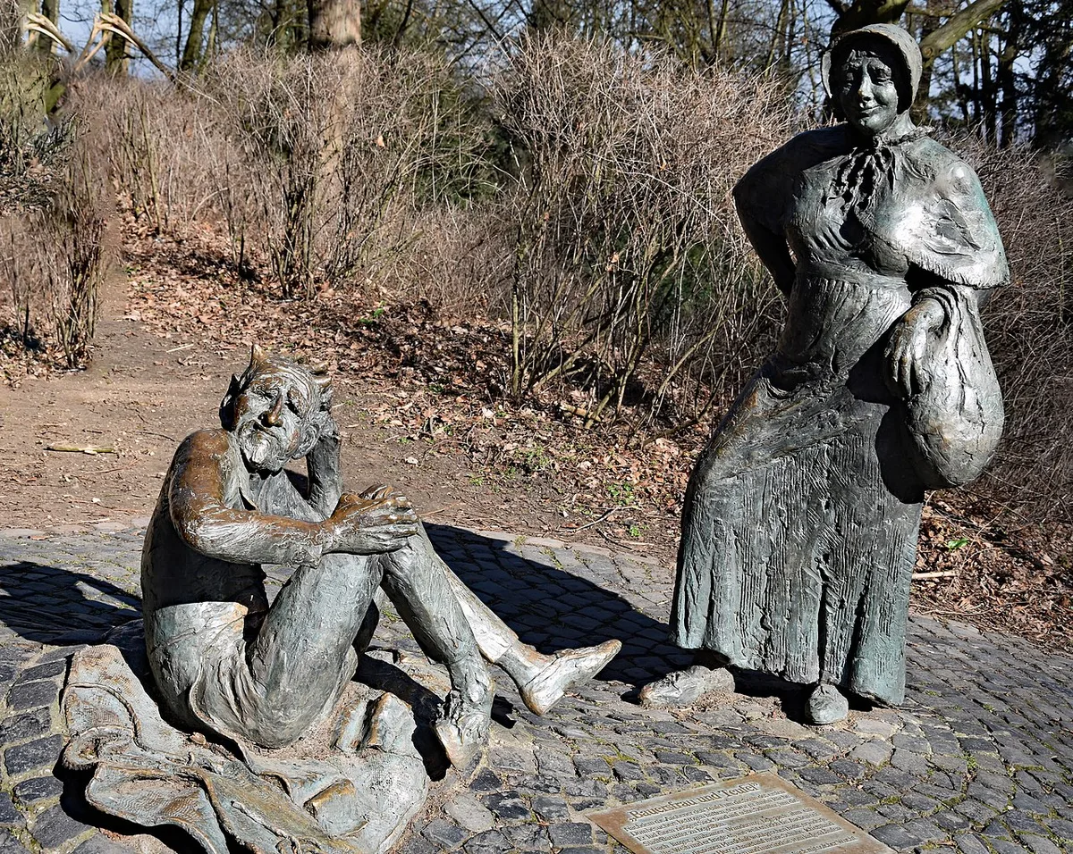
Near the start of the documented loop you also pass a statue depicting the market woman and the devil from the Lousberg legend, and the Hotmannspief fountain, a monument erected in 1825 at a water point that has existed since prehistoric times. These early stops make the first kilometre more interesting than a plain suburban approach.
Route Option 1: The Full Loop from the City
The longer option is a loop from Aachen recorded at 8.37 kilometres with 140 metres of elevation gain, last updated in August 2026. It is categorised as moderate and as requiring good fitness, so treat it as a half-day walk with stops rather than a quick dash.

The route starts near a bus stop and returns to one, which makes it straightforward to reach without a car. It passes the fountain, the legend statue, the sundeck, the hammocks, the Soers viewpoint, the columns, the Town Hall viewpoint and the obelisk in sequence before closing the loop.
The surface is genuinely mixed: roughly 4.56 kilometres of gravel, about 1.63 kilometres of paved surface, around 1.45 kilometres of asphalt and some 668 metres of natural ground, with smaller amounts of other path types. That mix is the strongest argument for shoes with grip rather than smooth-soled city trainers, especially after rain.
Route Option 2: The Shorter Circuit Around the Tranchot Obelisk
The shorter documented circuit from Aachen comes in at 6.12 kilometres with 100 metres of climbing, and it is graded easy rather than moderate. It is the better choice if you want the viewpoints and monuments without committing to the full ridge.
Because it still connects the Tranchot Obelisk with the Soers viewpoint, you are not sacrificing the main sights by choosing it. What you lose is some of the quieter woodland and the sense of crossing the whole hill, which is exactly what the longer loop adds.
A third documented variant starts from Tivoli and runs 9.18 kilometres with 140 metres of climbing, again categorised as moderate. That option suits walkers already based near the stadium rather than in the centre, and it shows how easily the hill can be stitched into different starting points.
Which Route Fits Which Walker
Choose the short circuit if you have an afternoon, are walking with younger children, or want to combine the hill with an old-town visit afterwards. Choose the full loop if you have a morning free and prefer a continuous walk that feels like a proper outing rather than a viewpoint stop.
The hammocks and the sundeck with swings are the clearest family-friendly features, since they give children something to do between viewpoints. Walkers with limited stamina can also treat either route as a there-and-back to the nearest viewpoint instead of completing the circuit.
Neither route is described as an accessibility route, and the surfaces and gradients differ from section to section. If you need step-free or wheelchair-accessible paths, or you are pushing a stroller, check the details with the city's tourism information before setting out rather than assuming the hill is fully adapted.
Timing the Climb and Reading the Weather
No season guarantees a clear panorama, so build flexibility into your plan rather than fixing a date far ahead. Visibility is the variable that matters most: the same walk can feel entirely different under a flat grey sky and under broken cloud with long views.
A practical approach is to check the forecast for the day itself and pick your window accordingly, since wind and incoming rain affect exposed viewpoints more than sheltered woodland. The route documentation includes weather information tied to the route, which is more useful than a generic city forecast for judging conditions on the ridge.
Late afternoon light tends to bring out the texture of the old town below, but that is a preference rather than a rule, and it depends on cloud cover. If your main reason for climbing is the view, leave room to move the walk by a day rather than committing to a single slot.
What Is Free and What the Walk Does Not Include
The hill functions as open public parkland, so the walk, the viewpoints and the resting spots such as the hammocks are free to use. That is the key distinction from Aachen's ticketed sights: you do not need a ticket, a reservation or a time slot for the Lousberg itself.
What the routes do not include is any café stop, parking arrangement or guided element, and no source consulted here sets out opening hours or booking requirements because none apply to the open grounds. If you want food or a guided history walk, arrange that separately in the city and treat the hill as the walking portion of your day.
Note also that the city publishes current information about services and closures on its own site, which is the right place to confirm anything time-sensitive before you travel. For orientation on how the hill fits with the rest of the city, the wider Aachen: Landmark Visitor Guides collection is a sensible starting point.
Combining the Lousberg with the Rest of Aachen
Because the hill sits on the edge of the centre, it pairs naturally with a city walk rather than replacing one. A common shape for a day is old-town sightseeing first, then the climb, then a slow return downhill as the light changes.
If you want to keep costs down, the hill works well alongside other free things to do in Aachen, since the walking itself costs nothing and the monuments are encountered along the way. Pairing it with paid interiors elsewhere in the city is a matter of taste, not necessity.
Visitors who want a contrast between the panorama and a formal collection often add the Aachen Cathedral Treasury visitor guide to their plans, since the two experiences are complementary rather than competing. Build the hill into the day as the outdoor half and keep the indoor visit for a different slot.
Plan Your Lousberg Walk
The Lousberg is best treated as a flexible half-day walk rather than a single attraction to tick off. Decide between the longer loop of 8.37 kilometres and the shorter circuit of 6.12 kilometres based on your time and energy, then let the weather decide the day.
Wear shoes that handle gravel and natural ground, carry water, and plan to pause at the viewpoints rather than rush between them. Confirm current city information before you travel if anything about access matters to your group, since the hill is open ground and conditions can change.
Give the walk enough time to enjoy the old town below and the woodland around you. The climb is modest, the entrance is free, and the reward is a view back over a city that looks different from above than it does from its streets.
Frequently Asked Questions
Is the Lousberg viewpoint free to visit?
Yes. The Lousberg is open public parkland, so walking the routes, reaching the viewpoints and using the resting spots such as the hammocks do not require a ticket or a booking. That is different from Aachen's ticketed interiors, which are separate attractions with their own arrangements. If you want to confirm anything time-sensitive, check the city's own information before you travel.
How long does the Lousberg loop take?
The documented loop from Aachen covers 8.37 kilometres with 140 metres of climbing, while the shorter circuit around the Tranchot Obelisk is 6.12 kilometres with 100 metres. Time depends on your pace and how long you linger at the viewpoints and monuments. Treat any duration you see as a suggestion rather than an official figure, and add time for stops.
What can you see from the Lousberg viewpoints?
The route passes a viewpoint over the Soers and another looking toward the Town Hall, plus a sundeck with swings facing the Eifel Valley. Because the viewpoints face different directions, the panorama opens up in stages as you walk. Visibility varies with weather, so a clear day gives noticeably longer views than a grey one.
Where does the Lousberg loop start?
The documented loop begins near a bus stop in Aachen and returns to one, which makes it easy to reach without a car. You also pass the Hotmannspief fountain and the Lousberg legend statue early on, so those make useful orientation points. If you prefer a different starting area, a variant from Tivoli also reaches the hill.
Are the Lousberg paths suitable for casual walkers?
The hill is walked by a wide range of people, and the shorter circuit is graded easy while the longer loop is graded moderate. The surfaces are mixed, with gravel, paved and natural sections, so grip matters more than technical skill. Anyone with reduced mobility, or pushing a stroller, should check access details before setting out.


