
Last updated September 2026: Two Tunnels Greenway Bath is the city's free, traffic-free route through two former railway tunnels south of the center. The linear path runs 3.8 miles between East Twerton and Midford, while the full Bath Two Tunnels Circuit extends to about 12.3 miles via the Kennet and Avon Canal. Families walking a short loop, day-trippers extending a visit beyond the Roman Baths, and cyclists linking into the National Cycle Network all use the same trailhead.
Two Tunnels Greenway Bath at a Glance
South Bath's Two Tunnels Greenway follows the trackbed of the old Somerset and Dorset Railway, closed in March 1966. Restoration work began in 2010, and the route reopened as National Cycle Route 244 on 6 April 2013. Combe Down Tunnel measures 1,672 meters, making it the longest cycling and walking tunnel in the UK. Inside, a light and sound installation called Passage plays as you move through the dark. Devonshire Tunnel, the shorter of the two, curves you out of the city and into the wooded slopes of Lyncombe Vale. As a repurposed railway route running underground rather than through streets, it counts among Bath's more distinctive lesser-visited sights. No admission fee applies anywhere along the route, despite "Book Tickets" wording that occasionally shows up in search listings for the attraction.
- Length: 3.8 miles (6.1 km) one-way, East Twerton to Midford
- Combe Down Tunnel: 1,672 meters, the longest cycling and walking tunnel in the UK
- Opened: 6 April 2013, after restoration work that began in 2010
- Cost: free to access, with no tickets or booking required
- Surface: flat asphalt, fully traffic-free on the linear route
Linear Greenway or the Full Circuit: Choosing Your Route
Two very different trips share the same tunnels. The short linear Greenway covers 3.8 miles one-way and suits a two-hour outing on foot or a quicker out-and-back ride. Riders and walkers looking for more distance can continue onto the Bath Two Tunnels Circuit, a roughly 12.3-mile loop that adds the Dundas Aqueduct and a stretch of the Kennet and Avon Canal towpath. Walk Wheel Cycle Trust, which now stewards the route, lists the circuit's surface as 76.5 percent traffic-free, with the remainder split between asphalt, firm unsealed track, and looser unsealed sections. Extra care is worth taking on the short stretch near Sydney Gardens, where the circuit briefly runs alongside the A36. Signed throughout as National Cycle Route 244, the corridor carries an Easy difficulty rating and links National Cycle Route 4 in the city center with National Cycle Route 24 about 2.5 miles to the south. Most people treat the linear path as a half-day option and save the full circuit for a longer outing with more planned stops.
| Route | Distance | Typical Time | Surface |
|---|---|---|---|
| Linear Greenway | 3.8 miles (6.1 km) one-way | 1-2 hours walking; quicker by bike | 100% traffic-free, asphalt |
| Full Two Tunnels Circuit | 12.3 miles (19.7 km) loop | About 1 hour by bike; up to 4 hours on foot | 76.5% traffic-free; 61.5% asphalt, 25.9% unsealed firm, 12.7% unsealed loose |
Inside the Tunnels: Devonshire, Combe Down, and Tucking Mill Viaduct
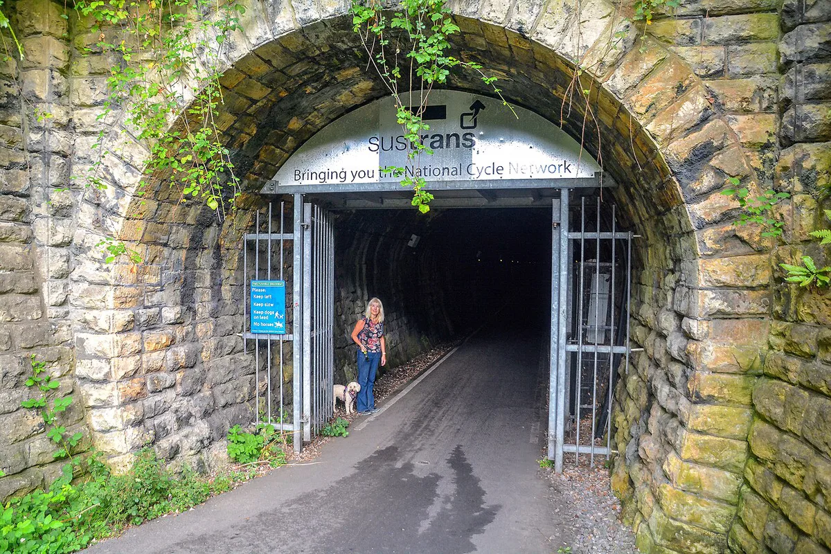
Leaving the edge of the city, the path curves through Devonshire Tunnel and into the wooded valley of Lyncombe Vale. A Portrait Bench marks the tunnel's entrance, a spot worth a short pause before the descent underground. Flooding at the Linear Park cutting near this tunnel was a recurring problem for years. A February 2025 drainage upgrade added an electric pump and filtration tank, addressing the standing water that used to collect at that end of the path. Lyncombe Vale's tree cover and steep valley sides feel far removed from the city center, just half a mile away. It connects naturally with other quieter parks and gardens around Bath for anyone wanting more green space nearby. Combe Down Tunnel follows next, a mile-long passage that runs 1,672 meters and climbs to the route's highest point at 91.4 meters above sea level. Temperatures inside stay noticeably cooler than the open trail, even on a warm summer afternoon, so a light layer is worth carrying regardless of the season. Motion-sensitive lighting activates as you move through, and the Passage installation layers sound and light along the tunnel's length. Past the tunnel, the trail crosses Tucking Mill Viaduct into open views before reaching Midford. According to the Visit Bath tourism guide, the Museum of Bath Stone sits about 0.25 miles from this stretch, covering the region's quarrying history for anyone taking a short detour. It pairs well with a wider look at Bath's smaller specialist museums if a rainy afternoon calls for an indoor stop.
The 3.8-mile linear route peaks at 91.4 meters elevation while passing through 1,672 meters of Combe Down Tunnel.
Getting There, Parking, and Bike Hire
Bath Spa Station sits just over half a mile from the Devonshire Tunnel end of the route, close enough to walk directly onto the path. Oldfield Park Station offers a second, quieter access point partway along the linear section, and Walk Wheel Cycle Trust recommends starting from either station if you're arriving by train. Day-trippers arriving from London can reach Bath Spa Station directly and treat the greenway as an easy add-on before heading back. London's own overlooked corners are worth a separate look on the return trip, covered in a companion guide to London's lesser-known neighborhoods. Drivers can look for parking near Linear Park on the Bath side or in Midford at the eastern end. Spaces are limited at both, so check current signage before relying on a specific spot. Several independent bike-hire operators work out of central Bath, generally clustered near the station and the shops along Walcot Street. Call ahead in peak season, since stock and daily rates vary by shop. Walking or cycling any section of the trail costs nothing. Only a hired bike carries a charge. The route itself carries no set opening hours and stays accessible year-round, though the Passage installation and tunnel lighting are easiest to appreciate before dusk. Planning a full day at minimal cost fits naturally with a broader look at other free activities around Bath if the budget is tight.
Where to Eat and Onward Cycle Routes
Midford marks the end of the main tunnel section and the start of several onward options. Hope and Anchor sits right at the trailhead, pouring beer from Wiltshire and cider from Somerset, according to the route's own trail notes. Cyclists continuing toward Monkton Combe pass Harry Patch's grave in the village churchyard before rejoining the Kennet and Avon Canal towpath toward Brassknocker Basin. Angelfish café, at Brassknocker Basin, makes a natural stop before the return leg past Claverton Pumping Station. From Midford, National Cycle Route 24 continues south toward Radstock. National Cycle Route 4 heads back into central Bath and on toward the separate Bristol and Bath Railway Path, a 13-mile off-road link to Bristol. Public transport backs up the ride too. A 94 bus links Monkton Combe to Freshford, and a 13 bus runs from South Stoke back into the city center, useful if legs or weather cut the ride short.
Who the Two Tunnels Greenway Suits Best
An estimated 265,000 trips are made along the Two Tunnels Greenway each year, a figure cited by trail campaigners pointing to its popularity as a model for other disused-tunnel projects elsewhere in the UK. That volume of use comes from several different kinds of visitor, each suited to a different stretch of the route. Active families tend to stick to the flat linear section between East Twerton and Midford, since it stays fully traffic-free and needs no technical cycling skill. Day-trippers based in central Bath often treat the tunnels themselves as the main event, walking in from Bath Spa Station and turning back after Combe Down Tunnel without continuing to Midford. Cyclists aiming for distance typically ride the full circuit, then continue onto National Cycle Route 24 or 4 to extend the day further. Runners use the same path early in the morning, when the tunnels tend to be quietest. Whichever group you fall into, the same tunnels and the same trailhead work for all three, so plans can change mid-route without backtracking far.
- Families: linear Greenway, East Twerton to Midford
- Day-trippers: tunnels-only there-and-back from Bath Spa Station
- Cyclists: full 12.3-mile circuit plus National Cycle Route 24 or 4 extensions
From Railway to Greenway: A Short History
The Somerset and Dorset Joint Railway once carried passengers and freight along this corridor, closing to trains in March 1966. Both tunnels then sat disused for decades, eventually passing into Wessex Water's care before a formal handover for reuse as a cycling and walking route. Restoration work on the western portal of Devonshire Tunnel began in March 2010, backed by National Lottery funding that supported similar Connect2-style projects across the UK. Combe Down Tunnel reopened alongside Devonshire Tunnel on 6 April 2013, completing the route in a single opening rather than a phased rollout. That single-phase opening is one reason the route still feels cohesive today, rather than assembled from separate later extensions. Tucking Mill Viaduct, part of the same railway, still carries the old operational nickname "Park Bank" among local rail historians. Midford Castle remains visible on the hillside above as the trail approaches the village.
Since reopening on 6 April 2013, the greenway has handled 265,000 trips annually, a number cited by campaigners demonstrating demand for traffic-free cycle routes.
Mistakes to Avoid and Trail Etiquette
Tunnel temperatures catch first-time visitors off guard, since both Devonshire and Combe Down stay noticeably cooler than the surface trail even in peak summer. Packing a light jacket for the underground sections is worth doing regardless of the forecast outside. Bells matter on a shared-use path used by walkers, runners, and cyclists at the same time. A quick ring before overtaking keeps things predictable for everyone. Dogs are welcome but should stay on a lead through both tunnels and on the busier sections near the city. Motion-sensitive lighting means the tunnels only brighten as you approach, so solo cyclists riding at dusk should carry a front light as backup rather than relying on the sensors alone. The permissive path between Wellow and Midford closes occasionally, with a hillier diversion route on those dates. Check current closure notices before planning a full circuit around that stretch.
- Ring a bell before overtaking on shared sections
- Keep dogs on a lead through both tunnels
- Carry a front light for solo rides at dusk
- Check Wellow-Midford closure dates before a full circuit
Frequently Asked Questions
How long is the Two Tunnels Greenway in Bath?
The linear Two Tunnels Greenway covers 3.8 miles (6.1 km) one-way, running between East Twerton and Midford. Riders and walkers wanting more distance can continue onto the full Bath Two Tunnels Circuit, a roughly 12.3-mile loop that adds the Kennet and Avon Canal towpath and the Dundas Aqueduct.
Is the Two Tunnels Greenway free, and do you need to book tickets?
Access is free, with no tickets, membership, or booking required to walk or cycle any part of the route. Some search listings show "Book Tickets" wording, but that doesn't apply to entry onto the greenway itself.
How long is Combe Down Tunnel, and is it lit?
Combe Down Tunnel runs 1,672 meters, making it the longest cycling and walking tunnel in the UK. Lighting is motion-sensitive, brightening as you approach, and the tunnel also houses the Passage sound and light installation.
Can you cycle the whole Two Tunnels Greenway, and where can you hire a bike?
Yes, the entire route is a shared-use path open to both cyclists and walkers, with a flat, asphalt surface throughout the linear section. Several independent bike-hire operators work out of central Bath near the station, so it's worth calling ahead in busier months to check availability.
What's the best way to reach the start of the Two Tunnels Greenway?
Bath Spa Station sits just over half a mile from the Devonshire Tunnel end of the route, making it the most direct starting point by train. Oldfield Park Station offers a second, quieter access point further along the linear section, and Walk Wheel Cycle Trust recommends starting from either station.
Where can you eat along the route?
Hope and Anchor, right at the Midford trailhead, serves beer from Wiltshire and cider from Somerset. Angelfish café at Brassknocker Basin, on the Kennet and Avon Canal towpath, makes a good stop on the longer circuit.
Is the Two Tunnels Greenway suitable for wheelchairs and pushchairs?
The linear section's flat, asphalt surface and gentle gradient make it manageable for pushchairs and many wheelchair users. It's worth checking current trail condition reports before a visit, especially after heavy rain, since the full circuit includes some unsealed sections that are harder going.