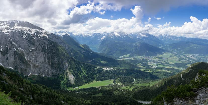

Berchtesgaden squeezes several distinct panoramas into a small corner of the Bavarian Alps. Within a short drive of one another you can look down a fjord-like lake, ride a cable car to a summit station close to 1,900 metres, or walk a near-level lakeside path with the Watzmann in view. The catch is that access differs sharply: some viewpoints need a boat, some a cable car, some a toll road, and some only your legs.
A useful first filter is elevation against effort. The Jennerbahn cable car climbs to a summit station at nearly 1,900 metres in a few minutes, while the Kehlsteinhaus sits at 1,834 metres and cannot be reached by private car. Comparing those two, rather than comparing summit heights, usually settles which viewpoint fits the day you actually have.
Choosing a Viewpoint by Access and Effort, Not by Ranking
The most practical way to choose between Berchtesgaden's viewpoints is to start from how you get there. Boat, cable car and toll road deliver you high or far with minimal walking, while the classic summit panoramas require sustained ascent. On the lake itself, the landscape around the Königssee can only be explored by boat, as the regional tourism board notes in its Königssee pages, so the shoreline viewpoint and the ferry crossing are two different commitments.
Cost structure also varies, so do not assume one ticket or one fee covers everything. The Rossfeld Panorama Road charges a toll per vehicle at its north and south toll booths, while the Zauberwald forest and the Hintersee shore are described by the regional tourism authority as freely accessible at all times. A third consideration is orientation: the viewpoints above the Königssee face the Watzmann massif, whereas the Rossfeld plateau opens toward the Hoher Göll, the Tennen and Dachstein ranges and, on clear days, the Salzach valley toward Salzburg.
If viewpoints are the backbone of your trip, the Berchtesgaden landmark guides collect the individual attractions with their access details in one place. Use them to check how each site is currently operated, then match the list to the hours you really have. Two viewpoints in one day is realistic; three usually means brief stops rather than lingering.
Kehlsteinhaus and Obersalzberg: The Historic Summit Panorama
The Kehlsteinhaus, often called the Eagle's Nest, sits at 1,834 metres and combines a difficult history with one of the widest panoramas in the region. The regional tourism board describes it as a building erected during the Nazi era that now serves both as a historical reminder and as a remarkable viewpoint, with the panorama stretching across Berchtesgaden and into Austria. The approach is part of the experience: a winding road cut into the rock, followed by a gold-plated lift that carries visitors up through the mountain.
Access is restricted, which shapes the day. Visitors cannot drive themselves to the summit; they park below, and one widely read travel account describes leaving the car near the Documentation Centre at Obersalzberg and hiking up instead. The same account puts the climb at a little over 900 metres of elevation gain and roughly two hours on a steep trail, making it a half-day undertaking rather than a stroll. Treat that walking time as a source-dated account of one route, not an official figure.
Because the site is historic and managed, its operating calendar is seasonal rather than year-round and the shuttle arrangements are set by the operator, so check the current season, ticket scope and any closure notices on the official Berchtesgaden pages before building a day around it. The Dokumentation Obersalzberg below is a separate attraction with its own admission, opening hours and collection, so do not assume one ticket covers both.
Mount Jenner Above the Königssee: Cable Car Views Without the Climb
Mount Jenner is the counter-argument to hiking for your panorama. A modern cable car lifts passengers to a summit station at nearly 1,900 metres, and the regional tourism board describes the result as sweeping views over the Watzmann, the Königssee below and large stretches of the national park. Because the ascent takes only minutes, the Jenner suits travellers with limited time and anyone who wants a summit view without the summit effort.
The trade-off is that the summit area is broad rather than a single ledge, so the best views come from walking a short way along the marked panoramic paths. From up here you look across to the Kehlstein and the Watzmann rather than standing on them, which makes the Jenner a natural companion to a lake visit rather than a substitute for one. The Jennerbahn cable car and summit guide covers the summit paths and facilities in more detail.
Above the tree line there are also mountain restaurants on the Jenner, which makes it feasible to combine lunch with the view rather than descending hungry. A bus or car is still needed to reach the base station at Schönau am Königssee, and cable car operating periods and service intervals should be confirmed with the operator. Ticket prices change over time, so treat any figure you read elsewhere as a date-stamped snapshot.
Rossfeld Panorama Road: A Summit Plateau You Can Drive
The Rossfeld Panorama Road is the region's drive-and-look option, and the name is slightly misleading: it is a loop with a genuine summit section rather than a through route. The road climbs to around 1,600 metres, and its summit stretch crosses a high plateau, part of it on Austrian territory, with roughly 1.5 kilometres of road lying beyond the border. Views from the summit section take in the Hoher Göll massif, the Kehlstein, the Untersberg and the Salzburg plain.
There are two approaches, which matters if you are combining viewpoints. The south ascent runs from the Obersalzberg via the south toll station and passes the starting point for the hike up to the Eagle's Nest, while the north ascent begins in Berchtesgaden-Oberau. That geography makes a natural pairing: an Obersalzberg morning followed by the Rossfeld loop in the afternoon, with no backtracking.
The road operates as a private federal road, with maintenance and administration financed from toll revenue, and the operator publishes the current rates and vehicle categories. Because tolls, seasonal maintenance and winter arrangements are set by the operator and change over time, confirm the current figures and open status directly before setting out. Overnight stays and camping in vehicles anywhere along the route and its car parks are not permitted, and the operator provides roughly 400 parking spaces at the viewpoints for daytime stops.
Königssee Viewpoints: Malerwinkel and St. Bartholomä
Some of the finest views of the Königssee do not require gaining height at all. The Malerwinkel loop above the northern shore delivers the classic angle down the lake toward St. Bartholomä and the Watzmann east face, and the regional tourism board lists it as a roughly 5-kilometre round walk with about 160 metres of elevation. That profile puts it in the short-visit category rather than the hiking-day category.
Further into the lake, the electric boats cross to St. Bartholomä, where the pilgrimage church with its red onion domes sits beneath the Watzmann. The tourism board notes that the boat crossing from the Seelände to St. Bartholomä takes about 35 minutes each way and suggests allowing at least two hours for the outing, and that the church itself can be visited free of charge. Those timings are planning suggestions rather than a guaranteed schedule, so check current sailings before you go.
Two practical caveats are worth knowing before you buy a ticket. The boats are not built for wheelchairs, with boarding over a narrow, fairly steep entry of three downward steps, though crew assist and mechanical wheelchairs can be borrowed in limited numbers at the ticket desk; electrically powered wheelchairs cannot be carried. Dogs travel for a fee and must wear a muzzle, and swimming in the lake is permitted but you must not enter the shipping lane. Online tickets are sold only for departures from the Seelände, not for one-way returns by hikers boarding at Salet or St. Bartholomä.
Hintersee and Zauberwald: Low-Angle Lakeside Panoramas
Not every memorable view in the region looks down from a summit. At Hintersee near Ramsau, emerald water, tumbled boulders and a mountain backdrop create a lower-angle panorama that rewards a flat walk rather than a climb. The regional tourism board describes the lake as freely accessible at all times and the surrounding Prinzregent-Luitpold-Weg as an almost level circuit that can be walked year-round.
The adjoining Zauberwald is the reason the setting looks the way it does. According to the regional tourism board, a prehistoric rock fall of roughly 15 million cubic metres of stone dammed the Ramsauer Ache and created both the forest and the lake, and the resulting landscape has been recognised as one of Bavaria's most beautiful geotopes. The walking route through the forest was laid out in the 1890s, while the name Zauberwald only established itself in the 1920s.
Because the terrain is gentle and the paths are maintained, this is the most family-friendly viewpoint combination in the area and a sensible choice on a day when cloud hides the high summits. Boats can be rented on the Hintersee in season, and the lake also serves as a trailhead for longer routes into the Klausbachtal. A mapped loop linking the Marxenklamm gorge, the Zauberwald and the lake shore covers about 4.7 kilometres and is rated easy.
Hike-to Viewpoints: Grünstein, Archenkanzel and National Park Trails
The national park maintains a network of around 260 kilometres of trails and alpine paths, graded from barrier-free and easy through to difficult routes with exposure and a risk of falling. The park authority advises tailoring any outing to your ability and the weather, carrying sturdy footwear, rain protection and food, and treating the signposts on the ground as the authority for a path's difficulty rather than any third-party rating.
Among the viewpoints that genuinely require effort, the Grünstein is one of the most popular targets, with a climbing route and a suspension bridge on the approach and what one hiking guide describes as exceptional summit views of the Watzmann massif, the Königssee and the Berchtesgaden valley. The same guide notes that a hut sits near the summit serving snacks and drinks, which softens the descent. Distances, times and grades vary by route choice, so pick a specific trail before setting out.
Other high viewpoints in the park, such as the Archenkanzel above the Königssee, appear mainly on longer loop routes that combine several hours of walking with substantial altitude gain. Treat these as full-day objectives rather than add-ons, because the return leg is as demanding as the climb. The park's own hiking pages and the tourist board's tour listings are the right places to check current conditions and any trail closures.
Matching Each Viewpoint to Your Trip Style
For a short visit with minimal walking, the Jenner cable car, the Rossfeld loop by car or bus, and the flat Hintersee circuit are the three strongest candidates. All deliver a wide panorama without a sustained climb, and all can be slotted around a half-day commitment. If you have only one clear morning, pick the option whose access matches your transport rather than trying to combine two.
For travellers willing to walk for their view, the Kehlstein hike and the national park summit routes offer the more earned panoramas, with the Grünstein, the Archenkanzel and the Kührointalm among the classic targets. These belong to full-day planning, need an early start and depend heavily on weather and daylight. On the lake itself, the Malerwinkel loop is the useful middle ground: a real walk with real views, but short enough to pair with a boat trip or an afternoon in town.
When cloud sits low over the summits, shift to the valley-floor options rather than cancelling the day. The Zauberwald and Hintersee walk stays rewarding in soft weather, and for a wet day the Dokumentation Obersalzberg offers an indoor alternative with its own admission and a permanent exhibition including the bunker complex. Check its opening hours and any maintenance closures on the operator's visitor page, since the museum does publish temporary closure periods.
Practical Planning: Verifying Details Before You Go
The single most important habit for viewpoint planning here is checking live sources rather than relying on saved articles. Boat, cable car, toll and museum details change by season and year, and a blog written in a previous season may describe an arrangement that no longer applies. The regional tourism board and the individual operators publish the current information, and the gateway page for Berchtesgaden landmark guides links the individual attractions in one place.
Transport is the second variable. The Dokumentation Obersalzberg, for example, recommends taking bus 838 from Berchtesgaden main station and alighting at its own stop, and it notes that car parks can fill in summer. If you plan to rely on buses, keep in mind that service levels, route numbers and seasonal timetables vary, and confirm them with the local transport operator rather than assuming a year-round schedule.
Third, keep weather flexibility in your plan. Mountain weather changes quickly, high routes can be affected by snow outside the main hiking season, and the park authority notes that the weather can shift rapidly in the mountains. Building one interchangeable indoor or valley option into each day avoids wasting a ticket or a toll on a view you cannot see.
Sequencing Two or Three Viewpoints Without Duplicating Effort
The efficient way to combine viewpoints in Berchtesgaden is to group them by access corridor rather than by reputation. Pair an Obersalzberg-area morning with the Rossfeld loop, since the southern toll approach begins near the Obersalzberg and the road's summit section is only minutes away. Keep the Königssee viewpoints, whether the Malerwinkel loop or the boat to St. Bartholomä, in a separate block, because the crossing and the shore walks consume a half-day on their own.
If you want a late-afternoon viewpoint rather than a midday one, plan the day so the final stop is one you can leave without a long descent in fading light. The Berchtesgaden itinerary and city pages, along with the dedicated sunset guide, help you slot viewpoints into a realistic sequence. Then confirm the current toll, ticket and opening details with each operator before you leave, and treat every price you read elsewhere as a date-stamped snapshot.
Frequently Asked Questions
Which Berchtesgaden viewpoint is easiest to reach without hiking?
The Jenner is among the simplest of the high panoramas, because a cable car carries you to a summit station where marked panoramic paths lead to the best angles over the Königssee and the Watzmann. The Rossfeld Panorama Road is the other low-effort option, since you can drive or ride to its summit plateau and use the parking areas at the viewpoints. If you prefer to stay near the water, the near-level circuit around the Hintersee involves almost no climbing at all.
Is the Kehlsteinhaus or the Jenner better for panoramic views?
They offer different things, so neither is objectively better. The Kehlsteinhaus stands at 1,834 metres and pairs a wide panorama across Berchtesgaden and into Austria with a significant historical context, but you cannot drive yourself up and the approach involves either the shuttle or a steep hike. The Jenner is quicker to reach, has an easier summit area to walk, and looks across to the Kehlstein rather than standing on it, which suits travellers with limited time or limited mobility.
Can you see the Königssee without taking the boat?
Yes. The Malerwinkel loop above the northern shore gives you the classic view down the lake toward St. Bartholomä and the Watzmann east face, and the tourism board lists it as a walk of roughly five kilometres with about 160 metres of elevation gain. What you cannot do without a boat is reach St. Bartholomä itself or the inner lake shore, since the tourism board notes that the surrounding landscape is only accessible by water. If you do take the crossing, allow at least two hours for the round trip to St. Bartholomä.
How do you reach the Rossfeld Panorama Road viewpoints?
Most visitors arrive by car or motorcycle, entering via the south ascent from the Obersalzberg or the north ascent from Berchtesgaden-Oberau, and paying a toll at one of the two stations. The operator publishes current rates for cars, motorcycles and buses. If you do not have your own vehicle, seasonal bus services have been used by visitors, but you should confirm current routes and timetables with the local transport operator before relying on them.
Which Berchtesgaden viewpoints suit a short visit versus a full-day hike?
For a short visit, the Jenner cable car, the Rossfeld summit plateau, the Hintersee circuit and the Malerwinkel loop all fit comfortably into a few hours. The Kehlsteinhaus hike and the national park summit routes, such as those toward the Archenkanzel or the Grünstein, are full-day objectives that need an early start, good weather and adequate equipment, and the park authority advises matching any route to your fitness and the conditions on the day.
Sources
- Berchtesgaden | Urlaub in Bayerns schönster Ecke am Königssee | Berchtesgaden
- 10 Best Things to Do in Berchtesgaden (2025 Guide)
- 13 best hikes in Berchtesgaden National Park, Germany
- Top sights in Berchtesgaden | Königssee, Eagle’s Nest & alpine highlights | Berchtesgaden
- Hikes in the Berchtesgaden National Park
- Der Hintersee bei Ramsau | Berchtesgaden
- Der Zauberwald am Hintersee |Bergsteigerdorf Ramsau | Berchtesgaden
- Marxenklamm Gorge – Bridge over the Ramsauer Ache loop from Hintersee | hike | Komoot
- Der Königssee | Berchtesgaden
- Your visit - Dokumentation Obersalzberg
- Rossfeld Panorama Road | Berchtesgaden
- Rossfeld Panoramastraße: Usage & Info